| Weather: Partly sunny with gale force Westerly |
| Distance covered today: 22.3km ( 13.9mi) |
| Last night's B&B: The Bays Guest House |
| % Complete: Cumulative distance: 76.2 %: 124.7 km |
| GPS satellite track of today's route: Day 6 (click!) |
Although not scenically spectacular, today’s walk was by far
the most interesting of the trip to date, and worth making a special effort to
do it, even if one has no intention of doing the whole thing. I would also say that for birders,
particularly those interested in seabirds, this leg is a must. Vast numbers of
many species of birds were making use of the salt marshes on the seaward side
of the sea defence barriers. I don’t
even know whether this is a good time of year to view them? Of course I know as much about birds as I
know about wild flowers, which isn’t helpful, and I had neither binoculars, nor
a bird-book. What’s more, my little
compact camera is no match for the proper equipment required to do these guys
justice. Perhaps the only downside of
the day was that given the birds, there were indeed lots of birders, weighed
down with expensive equipment and presumably resentful of my lack of stealth as
I powered along the track amidst a sea of flapping wings and alarm cries as the
birds headed for the hills, or more likely, Scandinavia.
I say the birds were mostly on the seaward side of the defences,
but that wasn’t always true. In at least
three places, I saw evidence of recent emergency repairs to breaches in the sea
wall. During the recent floods, most
media attention was focussed on the other side of Britain, particularly on the
Somerset Levels, the coast of the South West and the Thames. Preceding those crises, there was a
confluence of circumstances which threatened coastal communities in East Anglia
and brought back memories of the fatal floods of 1953 when hundreds of people
were killed, including 60 between King’s Lynn and Hunstanton. Sea
defences burst in more than 1,000 places and thousands of people were
displaced.
The problem occurs at a time of seasonally high spring
tides, when there is a very strong depression over the North Sea driving vast
volumes of water down towards the bottleneck of the English Channel, amidst
huge waves and high winds. Following
that tragedy, East Coast defences were greatly strengthened and indeed, the
Thames Barrier was eventually built to prevent London from flooding. The problem recurred in December 2013, and
while everyone was expecting the worst, the defences held for the most part and
although two people were tragically killed and a house or two fell into the sea
as a result of coastal erosion, the media caravan moved on in time to the less serious
floods in the West.
The Norfolk Coastal Path website had warned me that the trail
had been compromised in places by the floods and I assumed that these would be
where the sea walls and the trail coincided. (I was informed that repairs would
be more or less complete by Easter, so I decided to take the risk. As it turns
out, I was wrong. Tomorrow’s walk is compromised and I’ll have to find another
route after I post this blog!). Of
course, once the wall has been breached and the sea has rushed landwards,
nothing much can be done until the flood is over, by which time the landward
side is under water. Fixing the sea wall at this point means that the water can’t
flow back to sea when the tide recedes. The incongruous result is that viewed
from the sea wall, all plains on the landward side appear waterlogged, while at
low tide, the salt plains on the seaward side appear quite dry! The birds
probably appreciate this, even if everyone else, especially the farming
community, doesn’t!
The sea walls are more interested in height above sea level
than in straight lines, so my progress today was via a delightfully meandering path
that sometimes even, rather frustratingly, doubled back on itself, following
the contours of the coastal plains and their disruptive rivulets. The effect
was a constantly changing perspective, of subtle browns, greys and the odd
green field on the landward side. All of a sudden, the path made a bolt for the
sea; the earthworks turned to boardwalks, the dunes were breasted and I walked
a delightful 5km (3mi) along a broad, flat beach, with gale-force winds pushing
me along from behind and the sea frothing away merrily on my port side. There was hardly a soul on the beach, and
those I saw were as exhilarated as I was!
Then again, it all changed as I approached my destination
and was greeted by the holiday attractions of a coastal resort, with its usual
complement of sullen and bad-tempered families, out with the kids at half-term,
with everyone hating the weather, each other and life in general. Admittedly the wind was very strong and
bitterly cold, and as I have noted before, one gets used to these things over
long walks, but get out of your air-conditioned Beemer, and the blast is enough
to set your teeth on edge, especially when the kids are screaming, and the
in-laws are asking whose idea this was anyway! And so they all head for the
tacky attractions of the resort, because there isn’t anything else to do!
As it happens, Wells-by-the-Sea is a moderately attractive town,
with an extant fishing fleet and the B&B I’m staying in is very
comfortable. My mood this evening was very much improved by two encounters. The
first was with the Wells Carnival Committee.
I was sitting in the pub, preparing my data, minding my own business and
all of a sudden the committee descended. I couldn’t help overhearing the proceedings. There was that rather formal, slightly
bureaucratic approach to meetings so redolent of volunteer committees of
enthusiastic amateurs. Minutes were formally read, the treasurer’s report was provided,
and someone offered to get drinks from the bar. After the initial awkwardness,
someone cracked a joke and they all erupted. All discipline was lost and a
party ensued. It could have been off a
script from the Archers! I was hugely
amused!
I went to the loo, and was accosted by a fellow who, seeing
my jacket, wanted to know if I was “off a boat”. He told me that he skippered a “smack”, and
they had shipped anchor this afternoon, but when he reached the “bar” and saw
the size of the seas in that gale force westerly, he turned tail and repaired
to the pub instead; he wasn’t sure he had enough draught in that tide. He had
that wonderful estuary marine accent that convinced me he came from the East
End and so he did. He also told me he
had walked the Pennine Way, and when I explained my exploits he tried very hard
to settle me in. I could see where it was going, and extracted myself on what
for him was a lame excuse; the Chelsea game!
Thank goodness I did, because I might not otherwise have
been capable of navigating my way around the breached flood defences tomorrow!

Eek! I don't have any tide tables!

Not to worry guv, no water!

But there had been a lot, and recently!

Well, not on my land anyway! (There are numerous paths from the harbour to the main road, where any number of animals could be landed. This little Englander is nevertheless doing his duty, and he was of course flying the flag! It is visible in the background.)

An Oystercatcher!!!!

I have absolutely no idea!

One of three breaches in the sea wall that I came across today that have been recently repaired...

So that the standing water is on the landward side....

And at low tide, the seaward side seems quite dry!

A working windmill, but it wasn't working in today's gales

A roller-coaster path over a destoned field

My motto, at last!!

A squall looked as if it would catch me. It missed!!

Heading for the dunes on the sea wall....

Which then turned into a boardwalk.....

And finally I reached the dunes themselves; shades of Betty's Bay....

And an angry sea!

Holiday makers, yuk!

By the hundreds.....

These boats service the offshore turbines

And so to the traditional (almost) fishing port of Wells-by-the Sea
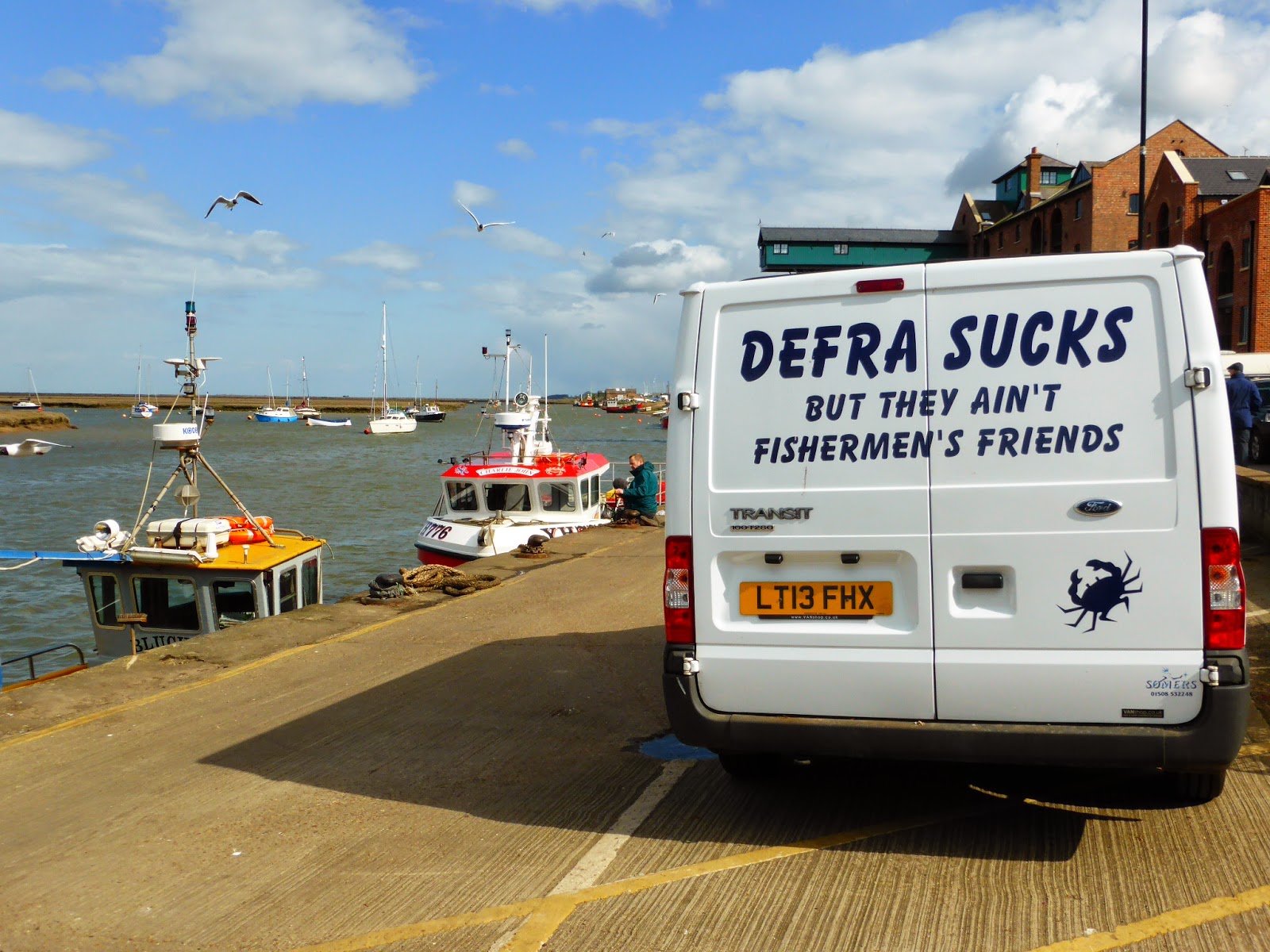
Where they don't like the Department of Fisheries and Rural Affairs! (Fishermen's Friends are also a brand of strong peppermints!)

The fishermen's working boats
It seems that the Dutch windmill has only three vanes, at different angles? This would seem to be unsound engineering. ?
ReplyDeleteYour comments on floodwaters returning whence they came from and the whole 'science' of protective bunds and levees and sea walls brings to mind the extreme floods in Pakistan in 2010. At World Water Week that year, a brilliant and passionate Pakistani hydrologist described how the vast flood waters remained trapped behind the extensive flood water protection barriers and could not find their way back into the natural river system. This had the effect of prolonging the flooding by many months, as your photographs show. An aging mind prevents me from remembering his proposed remedies, but I seem to recall that they focussed on using the natural systems and terrain as a template, rather than just bulldozing it to bits. Interestingly, and apropos of your earlier blog on immigration, this young hydrologist was working for a prestigious British university...
No doubt even as I write this, he is being consulted by the Environment Agency. Of course, in this country, on top of the hydrology of which you speak, there is also environmental policy itself. The farmers are interested in yields and livelihoods. The environmentalists are interested in sustainable development and species preservation. The whole thing becomes hugely political. It is a big issue just after the floods, but as the weather improves, so the caravan moves on....
DeleteAs a further aside, I think your problem with the windmill is one of perspective. The mill is actually facing away from the camera, so that the missing vane is concealed by the body of the mill itself. I can confirm that it did have four vanes.
DeleteAhah -- as they say!
DeleteLovely to see al the fishing boats. They all look very prosperous which I find a bit odd considering how the fishermen are supposed to be having quite a hard time finding fish.
ReplyDeleteThe 4th picture took me straight back to that tough 6 months when our animals were incarcerated. At least these days they are less extreme, on the whole.